Hyperspectral Imaging for Monument Preservation

Hyperspectral imagery for monument preservation offers a non-destructive examination of existing surface materials and mapping of the extend of foreign materials from previous restauration efforts. These imaging techniques can aid in the conservation and restoration efforts for monuments of historic importance, such as the baroque hereditary burial site in this example from a study by the German Research Centre for Geosciences Potsdam, GFZ shows.
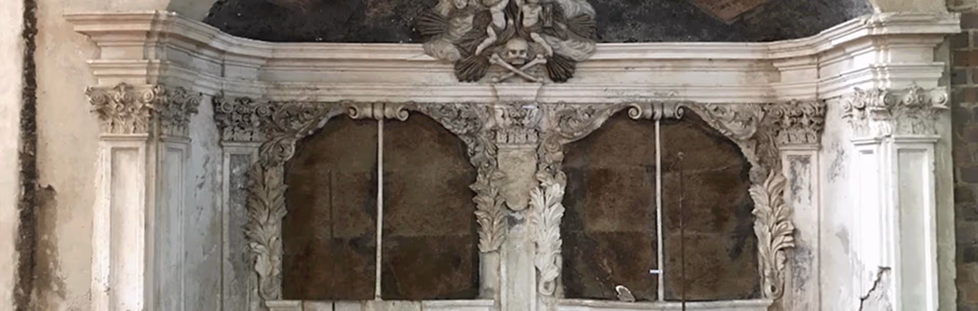
The baroque hereditary burial from the 17th century is located in the Eastern wall of St. Mary’s Church in Frankfurt (Oder), Germany. This particular burial site was walled in and only gradually re-appeared during repairs of the St. Mary’s Church after severe damage from 1945. Apart from damage sustained in the war period, the destruction of the Church’s roof and decades of weathering and moisture penetration led to severe losses of surface design. Changes in microclimate caused by opening and construction measures after 1982 caused salt crystallization processes and decomposition of the surface to occur.
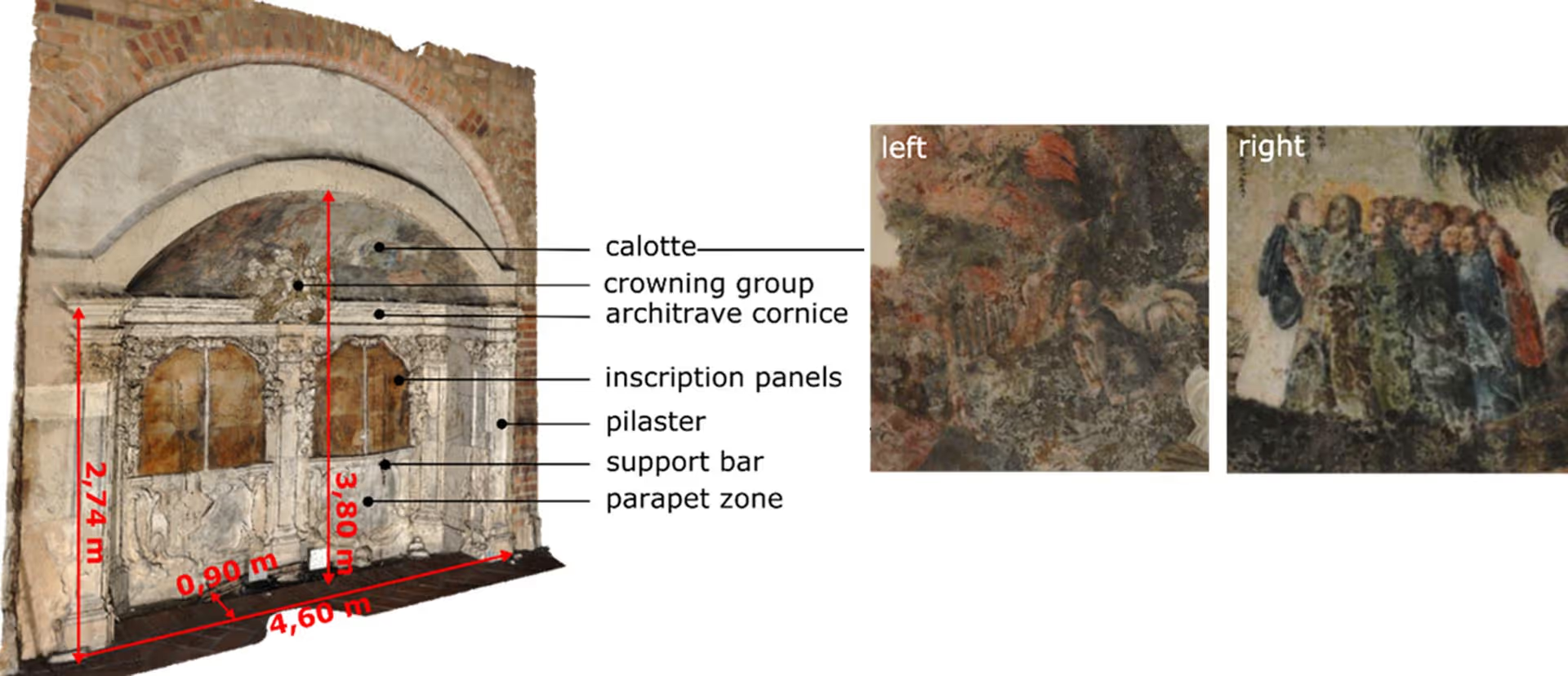
The different elements of the burial site are shown in Figure 1. It contains inscription panels framed in fine stucco decoration. The sides are lined by pilasters with Corinthian capitals and the parapet zone below the panels is decorated with stucco motifs of transience such as skulls and bones. Above the pilasters sits a stuccoed crowning group with angels, hourglass and a skull, topped by a calotte with an 18th century mural painting depicting biblical scenes.
The first conservation and restoration measures were carried out in 1983. Restorative measures included various adhesives, backfilling of hollowed out plaster, acrylate dispersions to fill defects in various aggregates and glass-fiber-reinforced epoxy resin to repair metal defects2. Different approaches to qualify these restauration measures and the overall state of the monument were tested in Köllner et al, 20211. Two of them will be highlighted here.
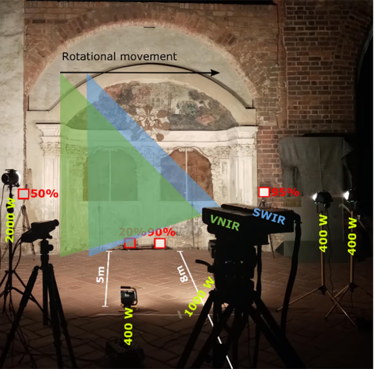
The epitaph was scanned using cameras from the HySpex Classic and Mjolnir series operating in the VNIR (400-1000nm) and SWIR (970-2500nm) spectral regions with a spectral sampling of 3.3nm and 5.5nm, respectively. They were operated from a motorized moving stage, scanning line-by-line in a rotational manner (Fig. 2). Five construction spotlights totaling 5200W were distributed over the entire length of the site at a distance of 5m. Four gray reference plates of different reflectivity values were placed in the scene for reflectance retrieval. Distinguishable materials on the surface were also sampled with a point spectrometer and compiled into a reference spectral library. More details on the scanning and correction of the illumination can be found in Köllner et al, 20211. The data analysis was performed by the GFZ hyperspectral geology group around Nicole Köllner in cooperation with the University of Applied Science Potsdam in the Department of Conservation and Restoration.
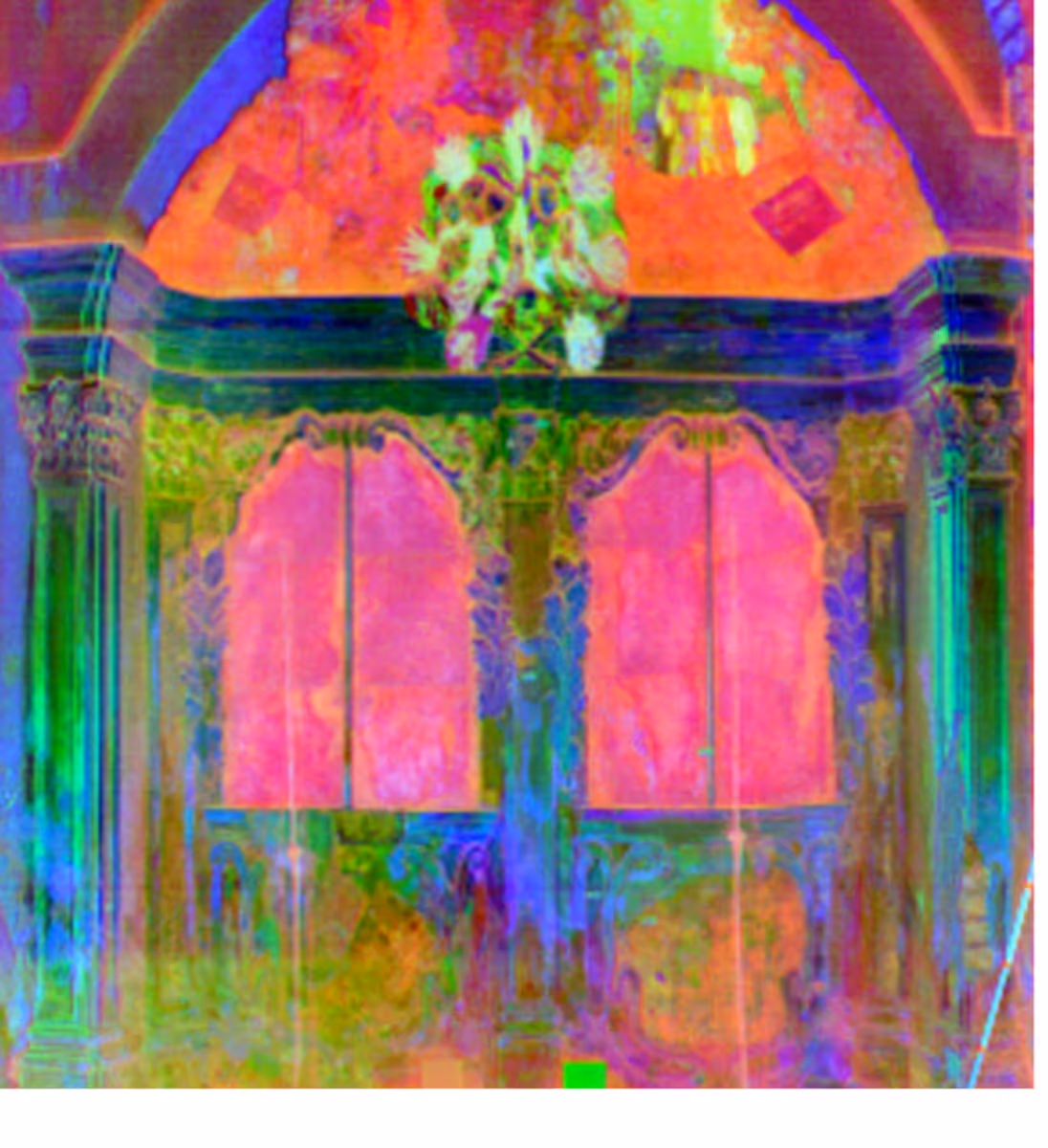
Initial information about the spectral differences of the building materials is provided by a principal component analysis (PCA). Fig. 3 shows the result as a color composite of the main components R: 1, G: 5 and B: 8 in the near to short wavelength infrared based on the co-registered HySpex data set. Identical colors within the image represent spectrally homogeneous surfaces. The high spectral variance of the stucco ornaments is particularly striking here. During the conservation measures between 1983 and 1985, the lime stucco ornamentation was restored, and the outcroppings were largely supplemented by hand.3 Presumably, these differ spectrally from the original lime stucco.
Spatial distribution maps for minerals, mineral groups and moisture can be generated by isolating the respective, known absorption features and calculating their absorption band position and depth. Two different minerals are mapped in Figure 4. Calcite with an absorption feature around 2320-2340nm and gypsum with its diagnostic feature around 1751nm, 2200nm and 2270nm. The carbonate absorption feature was calculated over a larger spectral range (2200-2400nm) as lime stucco may contain gypsum, aggregates and other binders in addition to carbonate components causing a shift in absorption feature position.
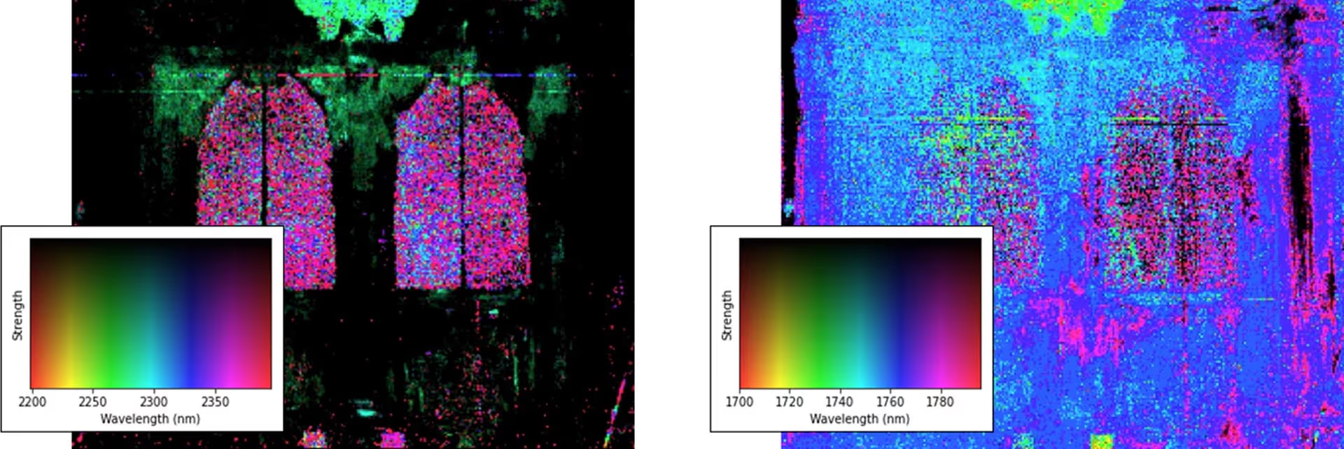
The spectral differences of the lime stucco (Fig. 4, right) highlights the compositional change in the supplemented vine ornaments (lateral frame of the panels, no feature), that deviates from the original stucco version (above the inscription panels, bright green). In the parapet zone in the base of the tomb, the formerly strongly sculptured lime stucco ornamentation has largely deteriorated or eroded. The gypsum absorption feature (Fig. 4, left) is pronounced on all plastered surfaces with no or missing color finish, excluding only the lateral supplemented vine ornaments. Changes in absorption position in the area of the crowning group results from differences in stucco mixture.
Measurements like these enable an inventory of the used materials, give information on the general conditions of the historical cultural asset and is a valuable data supplement to allow experts to review damage analyses on a larger scale to adapt their decision for restoration efforts. HySpex offers a varied selection of turn-key solutions for cultural heritage studies as well as other scientific and industrial applications.
Contact us to discuss your application and requirements with our specialists.


Download this application note →
References:
- Köllner, N., Mielke, C., Körting, F., Laue, S., Hildebrand, C., Kästner, F., Altenberger, U., Abbildende Spektroskopie im Nahbereich – innovative Methoden im Bereich der Denkmalpflege am Beispiel des „barocken Erbbegräbnisses“ in der St.-Marienkirche, Frankfurt (Oder), Brandenburg. In: Brandenburgisches Landesamt für Denkmalpflege und Archäologisches Landesmuseum, Thomas Drachenberg (Hg.), Bildgebende Verfahren – Trends und Fallbeispiele zur zerstörungsfreien Untersuchung und Erhaltung von Kulturerbe, Beiträge des 14. Konservierungswissenschaftlichen Kolloquiums in Berlin/Brandenburg am 12. November 2021 im Otto-Braun-Saalder Staatsbibliothek zu Berlin – Preußischer Kulturbesitz, Arbeitsheft des Brandenburgischen Landesamtes für Denkmalpflege und Archäologischen Landesmuseums, Nr. 61, 2021, in Druck.
- Klemm, B., 1989: Dokumentation, Konservierung und Restaurierung einer barocken Epitaphanlage an der östlichen Stirnwand des Südturms in der St. Marienkirche in Frankfurt (Oder). Unveröffentlichter Untersuchungsbericht, Brandenburgisches Landesamt für Denkmalpflege und Archäologische Landesmuseum
- Böwe, L., 2019: Barockes Erbbegräbnis in der St. Marienkirche Frankfurt (Oder) – Restauratorische Erstbegutachtung. Unveröffentlichter Untersuchungsbericht, Brandenburgisches Landesamt für Denkmalpflege und Archäologisches Landesmuseum.


